Monday, August 23, 2010

Practice makes better

A year ago today, August 23-24 2009,  Alan and I were out in the Dawn Patrol putting in some practice time scouting the WaterTribe's 100-mile NC Challenge race course.  At the same time Dawn was making a similar effort in her NDK Explorer sea kayak.  Practice makes..... better.   

It was a rewarding adventure sailing from the beach on Pamlico Sound to Beaufort.  Although we covered only the first half of the course on that trip, we became good friends with the Harlowe waterway (under 3 bridges),  the Pamlico/Neuse waters rounding Piney Island point (with bombing range),  and the Newport River/Taylor Creek approach to Beaufort.  We gained ~ 3.5 hours of rowing practice.    In the Neuse we inadvertantly capsized the Dawn Patrol for the first time (ever),   proved that it was no big deal,  and gained the confidence to go back home and routinely practice capsize-and-recovery drills (on purpose).

“It’s a dingy, and capsize and recovery is a normal expectation”.  --Alan


Day1 and Day2


I previously posted a report of this scouting trip in the B and B Yachts Forum on the Mess-About website,  along with  45 photos and 4 weather charts posted on Picassaweb. 

Recently I took a new look at the GPS data for our sailing and rowing from that 2-day scouting trip. Here are those data along with a few highlights...


Day 1

The winds on the Pamlico Sound were initially light as we rounded Piney Island into the Neuse River.  We occasionally rowed in the hot sun for a moment or two whenever the sails hung lifeless and the Pamlico turned to glass.  By 2pm the afternoon storms had kicked in to send us beating through sizable chop up the Neuse in 16 knot winds with 20-24 knot gusts.  I was at the helm when we capsized.  Twenty minutes later we were all bailed out,  none the worst,  and on our way reefed to the max in increasing winds. 

The storms cleared away the heat of the day left us in cooler air.  By 6:40pm we needed to shake the reefs out. By 8:00 pm the wind had died.  In the cool of the evening I rowed for an hour to bring us to a good stopping point and anchorage in the mouth of Clubfoot Creek  --gateway to the Harlowe waterway.  As we glided along during that hour, the stars were out overhead,  silent lightning flashed in the far distances,  Alan prepared a hot dinner for us,  and for some unknown reason we were treated to a fireworks display in the sky over Morehead City / Beaufort  (our destination) on that moonless night.      


Key: GPS speed (black dots connected by tan lines), smooth curve (red), rowing (tan rectangle).
Garmin GPSmap 76CSx was set to record [lat, lon] and time at 20-second intervals.


Day 2

At 7:00 am we sailed off our anchor, stopped for 5 minutes at Matthews Point Marina for water, and then short-tacked the first 3 miles into Clubfoot Creek.  The next 2.5 hours introduced us to rowing into a 1.5 knot current through the beautiful Harlowe Canal and its three faces:  the gentle Neuse River flora and fauna of Clubfoot Creek,  skirting the Croatan National Forest via the narrow canal under a canopy of trees and spanned by three low bridges,   winding through the lush green and brown marsh grasses of Harlowe Creek to reach the open tidal waters of the Newport River.  It was another hot day but we had a wonderful adventure discovering the Harlowe waterway and verifying that we did indeed fit under the three bridges with a few vertical inches to spare.  Piece of cake.  

Rowing through Harlowe Creek


The ride on the Newport River into Beaufort on 13-17 knot winds was fast.  We reefed.  Approached the draw bridge and sailed through when it opened with oars at the ready. 

Then passing "Check Point #1" (CP)  we sailed on down Taylor Creek to the public boat ramp. Dawn was waiting for us (of course!) at a public boat ramp.  The 5-10 knot gusty wind blowing toward the ramp, together with low-tide banks of oyster shell and mud to the right and left conspired against us;  ultimately,  Dawn backed the trailer down the ramp into the water and Alan sailed the Dawn Patrol up unto the trailer. 


Key: GPS speed (black dots connected by tan lines), smooth curve (red), rowing (tan rectangle).
Garmin GPSmap 76CSx was set to record [lat, lon] and time at 20-second intervals.


We were out of the water by 5:25pm.   Dawn did not believe we capsized. As we told her about our weekend, we finally convinced her that we were not pulling her leg, and she was glad we had that experience under our belts.  We had cruised and scouted the first 65 miles of the ~100mile NC Challenge.


A Month Later

A month later in the NCC 2009 race,  Alan and I sailed and rowed the same 65 miles in half the time --in large part thanks to cooperative conditions.  The other half of the race course (from Beaufort around Harkers Island and up Core Sound back to the start/finish line) was another story.


Friday, August 13, 2010

WaterTribe North Carolina Challenge (NCC2009)

The WaterTribe's second annual  North Carolina Challenge  is just around the corner:  in 41 days, 19 hours, 33 minutes.  Many WaterTribe challengers like to wait until the very last minute to sign up.  Perhaps psych-ing out the competition goes hand in hand with stealth camping and/or sailing at night.   Dawn encourged me to be a good example and go ahead and sign up,  so I recently got with it and added Alan and myself to the growing roster of challengers.  Sailing the Dawn Patrol, we will be in "Class 4" which includes all monohull sailboats. 

In 2010.  Like the NCC'09,  the NCC'10 will be a 100 mile race from a Pamlico Sound beach on Cedar Island down to a checkpoint in Beaufort via the Neuse River and Harlowe Canal and then back up to the starting point via Back Sound and Core Sound.  As in 2009 there will also be a 50 mile race from Cedar Island down to Beaufort for those who prefer that distance.   Both races start together at 7:30 am on Friday September 24.

In 2011.  Next year there will be three races:  50 mile,  100 mile,  200-300 mile.   That new long race on the drawing board will be on a par with the venerable WaterTribe Everglades Challenge (EC).   Or, some of us suspect it could be even tougher than the EC.


A Look Back at NCC '09

Here's a look at some data from the wonderful adventure Alan and I enjoyed last year in the NCC'09 sailing and rowing the Dawn Patrol.  (No motors allowed!)

107 mile track recorded by GPS

Weather History 

Friday 25th  (Day 1 on the Neuse River and at Beaufort)
     AM:  winds  5-10 mph from the WSW becoming WNW
     PM:  winds 15-22 mph from the NE, max gusts 26-32 mph
     Air temperatures 70-86 (F)

Saturday 26th  (Day 2 on Back Sound, Core Sound, and Pamlico Sound)
     AM:  winds 10-20 NE becoming E,  max gusts 26 mph
     PM:  winds 10-20 E becoming ESE,  max gusts 26 mph
     Air temperatures 70-78 (F)

Sunday 27th   (Others still on Core Sound and Pamlico Sound)
     AM: winds 5-10 SE becoming WSW,  max gusts 20 mph
     Air temperatures 70-80 (F)


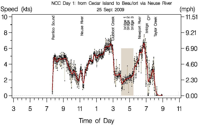
Figure 1:  GPS speed data for Day 1

The race started at 7:30 am on Friday September 25 with mild weather and good winds off the beach. On the Pamlico Sound the wind gradually faded.  Rounding Racoon Island into the Neuse River we rowed for a few minutes (11:15am).  Mid-day storms kicked in and sent us flying on a fast down-wind run up the Neuse River toward Clubhouse Creek.  The rains caught up with us there as we sailed up into the narrowing creek toward the Harlowe Canal.  In the canal we row/sailed or rowed in sprint mode (rowing highlighted by tan band).  The overcast sky and light drizzle of rain helped keep us cool as we rowed.  Otherwise, rowing on a hot humid day in full sun would have been much less pleasant.  Alan and I took turns rowing in 20 minute intervals.  Friends and family were waiting under their umbrellas on some of the first of the three bridges we passed under.  The current in the canal was initially unfavorable and less than 1 knot.  After rowing under the 3 fixed bridges the current became increasingly favorable.  Nearing our exit into the Newport River we had just about caught up with Graham Byrne's EC22, "Southern Skimmer",  the sky had cleared, the wind picked up,  and we were able to short tack out of the creek into the open waters of the Newport River.  We caught up with Graham and Randy at the draw bridge.  We heard the bridge master telling Graham on channel 13 that sailboats wanting to pass through should have auxiliary propulsion.  "Oh, I've got oars for that!" says Graham.  The bridge master was satisfied with that response.  We had our oars in ready position as both of our boats passed through the open bridge at about 7:00 PM.  As low tide was to occur at 8:10 PM,  the current through Gallant Channel under the bridge was favorable and minimal.  As we entered Taylor Creek the tidal flow was also minimal and we had no trouble sailing eastward on Taylor Creek.  In Taylor Creek on the Beaufort waterfront we spent a minute or two at the checkpoint (CP) and then found an anchorage at the east end of Taylor Creek for a few hours of sleep.


Key:  GPS speed (black dots connected by tan lines),  smooth curve (red),  rowing (tan rectangle). 
Garmin GPSmap 76CSx was set to record [lat, lon] and time at 20-second intervals.  


Figure 2:  GPS speed data for Day 2

It was a dark, humid, warm night.  At 3:30 am Alan happened to wake up and look out the window just as the "Southern Skimmer" sailed past our anchorage.  Oh no!   He was out of the door in a flash putting on his sailing clothes with one hand and raising the sails with the other hand while telling me to hurry up.   "Dad, let's go!"  At least I was sitting up, which seemed like good progress to me.  I was looking for my clothes having slept in just my underwear.  Alan: "Let's go, Dad!"    Paul: "Alan, I'm not dressed yet!"   Alan: "Oh.... in that case, as soon as you have your pants on we're going!"    I love you, Alan.  What a great son.  Rolling out of Taylor Creek and into Back Sound required very close attention to the chartplotter in order to navigate the shallows while tacking up-wind in the pitch black darkness.  No moon.  Couldn't see a thing.  The NE wind was 10-20 with gusts up to 26 mph.   Fortunately for me, Alan loves to sail at night and was as happy as a clam to press onward.  I, at that moment,  prefered to focus on the chartplotter in my hands.  Fully reefed and short tacking in Back Sound,  our speed bounced between 1 and 6 knots.  At that moment Graham and Randy aboard the "Southern Skimmer" had decided to pull off into an anchorage and sleep for 3 more hours.  We had no idea.  We were chasing, but chasing no one.   At dawn we wondered, "Where is Southern Skimmer?"  We spent a total of 8 hours beating upwind through big closely spaced chop on Core Sound wondering "Where is Southern Skimmer?".  The spray coming off the bow shot around the cabin and drenched both of us like a fire hose.  One of the registration letters on the starboard bow peeled off and was thrown into my lap.  Our speed was highly variable due to continually slamming into chop.  Consequently, our Anderson bailer in the sole of the cockpit could not keep up with the huge volume of spray coming in.  We found that we quickly had several inches of water in the cockpit if we stopped bailing manually.  Thank you very much, Core Sound.  "Where is Southern Skimmer?" we wondered.  We finally passed east of Chain Shot Island and Wainwright Island and turned west into Pamlico Sound at about 2:00pm.  The "Southern Skimmer" had taken a shorter route and at that moment seemed to "pop out" into Pamlico Sound just downwind of us.  They had eaten up the 3-hour lead we we had.  Now they would beat us to the finish line by 12 minutes. And, there streaking home along the shore was kayak racer Ardie Olson ("ArdieO") sprinting toward the finish.  He would beat us by 6 minutes.  Still reefed, we rode the big swells downwind planing at 8-10 knots.  What a ride!   Both Alan and I sat as far astern as possible and moved aft any other weight we could.  Ten minutes from the finish line, Alan lost one of his shoes overboard.  Folks on shore were baffled by seeing us suddenly sailing a tight 360.  After successfully picking up the shoe we finished the course.   Wow, what an adventure! 


Key: GPS speed (black dots connected by tan lines), smooth curve (red), rowing (tan rectangle).
Garmin GPSmap 76CSx was set to record [lat, lon] and time at 20-second intervals.


A year later, we rounded the same NCC'10 course but the weather conditions made that a completely different race.


--Paul

On-Deck Storage

The layout of the Dawn Patrol works well for a crew of two.  On-deck storage area around the cockpit includes space under the port and starboard coamings, space under the thwart,  and space under the fold-down rowing seats.
There's no denying that our nice dry cabin is a great place to toss gear for quick temporary storage when we are in a hurry.  To help organization, small storage hammocks contain small items and provide an attachment point for carabiners.  The cabin space is seven feet long, less than six feet wide, and less than four feet high   --just big enough for two people to sleep.  When the footwell is covered with its lid, the floor of the cabin is a single flat surface interrupted only by the centerboard trunk.

Carabiners sliding on a bungee under each coaming provide a way to clip small items (water bottles, map case, sunglasses case, etc) to the boat.

Either or both of the two rowing seats can be folded up or down.   The rowing crew can sit on either seat to row with one oar, or sit in the middle on both of them to row with two oars.   The rowing seats also offer a great place to sit protected from wind and spray. 

The 11' oars (Shaw and Tenney) are usually mounted under the coamings but can also ride in a 'ready' position flanking the cabin, resting in the oar locks with blades secured up near the bow.

For keeping food cool we carry a cooler that rides in the cabin's footwell while we are sailing.  At anchor we move the cooler to the cockpit where it sometimes serves as a small tabletop.  For daysailing we often carry a smaller cooler that can fit under the starboard rowing seat.

--Paul

Thursday, August 12, 2010

Within-Hatch Navigation

By the end of our 8-day 200-mile cruise in June with Spartina, Dawn and I could easily find items stored in the various hatches.  Having penciled in on a storage map at least a rough idea of where things were hiding was especially helpful at the beginning of the trip.  We had both contributed to packing the boat in a bit of a hurry.
This version of the storage map shows where everything finally came to rest after a whirlwind of packing and a day or two of sailing.  This figure is only intended as an aid to finding stuff,  and as an aid to thinking about where to put things next time.   Unlike a detailed checklist,  it does not say what exactly is in the "tool kit",  for example.  We picked up this idea from the Log of Spartina blog by Steve Early.  Here are links to some of Steve's posts about storage:


In one of those posts Steve said "I'll laminate this drawing back to back with a sheet of info about marinas, hotels and some other material and tuck it in with our charts."

Index of the day-by-day trip reports on Log of Spartina:


--Paul