Sunday, October 16, 2011

NCC 2011: Time Lapse Photography

Postcard from the edge:  The above image from a time-lapse series demonstrates the utility of side-deck coamings for keeping water out of the boat;  as here, when heeling at 24 degrees and burying the bowsprit in 3' waves and large rollers.  Here, crossing from Core Sound into Pamlico Sound,  the crew was hiking out on the starboard coaming.  Our portable battery-powered Atwood pump handled slosh.

Experimental Photography

In the 2011 WaterTribe NC Challenge (NCC) we, SOS and DWSB, experimented with time-lapse photography aboard the Dawn Patrol.  We used a Bushnell trail camera mounted on the tiller aft of the transom.   The camera took about four photos per minute during our 27 hours in the NCC.  The camera produced good-quality color photos during the daylight hours.  At night its invisible near-infra-red (IR) flash produced monochrome photos.  The camera uses 8 lithium AA batteries.  Between shots, it efficiently preserves energy to provide a battery life of weeks or months  --up to 12 months depending on the settings.

The camera has a 2" LCD review screen and can be used as a handheld camera for snapshots or video.  Or, it can be configured to run night and day for many weeks recording time-lapse photos.  It can also be set to record time-lapse video segments with sound.  Hunters would usually not use the time-lapse feature (a.k.a. "field scan mode"); rather, they would use its motion-sensor which triggers a photo or video segment whenever game stroll into view.  It can do both simultaneously: interval shooting and motion-triggered shooting.  In fact the only way to disable the latter is to blind the sensor with electrical tape.

The Photos

The good news is the camera took 5900 photos during our 27 hours on the water in the NCC aboard the Dawn Patrol.  The bad news is the camera took 5900 photos for us to sort through for use in time-lapse videos, slide-shows, or individual stills.  After tossing out blurred frames, over/under exposed frames,  and x-rated frames (changing clothes), we have 4589.  Here are some examples...

daylight color image
(Neuse River)
Twilight color image
(daybreak on Core Sound)

Twilight monochrome with IR flash
(Clubfoot Creek)
Night time still with IR flash
(Harlowe Creek)
Night time action with IR flash
(SOS spot-lighting markers in Newport River)
Backlit by late afternoon sun
Image taken when tiller was in motion
(Core Sound)
The Camera Mount

The camera was mounted on the tiller via a c-clamp camera mount with tether cord for security.  Just aft of the camera is the tiller's socket for the stern navigation light.  We chose to mount the camera in this location for several reasons:  We hoped that the occasional off-center positions of the tiller would help counter the camera's limited field of vision (50 degrees)  --but we knew the tiller would almost always be pointed straight ahead.  We hoped that the camera would not snag the mizzen sheet.  Putting the camera aft of the stern light would have blocked the stern light. 


                       Camera mount                                                                                          Side View
 The Camera

The all-weather camera was designed to be mounted on a tree trunk to create a photo-trap for discovery of game animals (deer, turkey, etc.) or bigfoot or poachers.  Mounted for an overnight test on the Dawn Patrol in our driveway, it captured the expected images as well as  --what else--  deer grazing in the lawn.
 

Model  #119456
"Bushnell 8MP Trophy Cam Night Vision Color LCD Digital Trail Camera"

Left:  2" LCD screen and control buttons,  8 AA batteries.    Right:  the back has attachment points, 
while the the front has an LED Array, a sheltered lens, and a motion detection sensor 

Left:  SD card slot, USB port, audio port, AD power,  mic (array of tiny holes)
Right:  hole for AC power,  rubber plug for hole,  1/4" camera mount socket
The camera housing is a hinged box with an o-ring seal  --similar to a small Pelican case.  We sealed the array of tiny microphone holes with electrical tape.  From the inside we applied electrical tape to seal the AC port's large, rubber-plugged hole.   These appeared to be the only obvious paths of potential water infiltration.  The camera is rated to handle splashes (rain), ice, etc.   However,  it is not rated for submersion as might occur during a capsize of the sailboat.

Array of 32 IR LEDs,  plus 2 center LEDs
that signal the status of the camera.
List of camera features:  8 mp resolution


Results

The camera worked well, about as expected,  in terms of the photos produced.  At night the IR flash was indeed invisible expect for a very faint red glow in the LED array  --which signaled to us when a photo was in progress.  The camera stayed dry and we did not capsize.

One disappointment:  the camera's clock was defective.  The correct date and time was stamped on each photo for the first 3741 photos, but then at 11:11pm the clock time-traveled to 08-10-2022 08:05am.   Then on the 3809th photo the clock jumped to the first minute of 01-01-2011.  After that the clock jumped on five other occasions to arbitrary times for no apparent reason.  Apart from these occasional episodes of time travel,  the camera continued to snap photos every 15 seconds, approximately, and kept accurate count of the time between frames.  Because of this clock defect we returned the camera for a refund.  We had no choice as having the wrong time stamps on the photos (and wrong creation dates on the JPG files)  was unacceptable.

Many thanks to that big NY camera store, B&H Photo,  for their outstanding customer service and free shipping in both directions.   I would buy from them again.

Lessons Learned

1.  A wider field of view would have been better!   We knew that,  and if time had allowed, we would have explored mounting a wider-angle lens on the camera before the NCC.  Several vendors sell such lens for use on iPhones and other cellphones.  (AGPtek)  

2.  A mount further aft might have been better.   This might not be necessary if a wider-angle lens is used. The camera could be mounted on a rigid boom 3' or 4' aft of the transom (not on the tiller).   The IR flash seemed too close to the cockpit.  In the night photos, we can see that the camera was too close to the mizzen sheets (ropes).  Occasionally, at night, one of the sheets moved in front of the lens and the IR LEDs flashed point-blank into the sheet causing washout of the entire photo.  When the mizzen sheets were slack they occasionally snagged on the camera.  On one such occasion at 3am the camera's aim was shifted to point at the cockpit sole and in the darkness we did not notice the shift until almost 6am.

3.  Comparison to video recording.   Waterproof compact cameras (here) and adventure video camera such as the GoPro HD Hero 960 can be submerged, have wide/wider angle lens, and are known to produce very good short segments of HD video.  For example, the Panasonic Lumix DMC-TS3 for snapshots and HD video has an 80 degree field of view.  And for example, the GoPro has a 170 degree field of view and records HD video (or time-lapse video) --but all subject to a battery life of about 2.5 hours.  How does recording a set of video segments compare to recording a set of start-to-finish time-lapse frames?   They both have their pros and cons, and their end results are complimentary.   For example, at the most exciting moments it may be difficult or impossible to activate/manage a video camera,  whereas the Bushnell camera never needed any attention.  On the other hand, when it is feasible to activate/manage the video camera the results can be great.  

What's Next?

We plan to post most of the time-lapse series.  We will break the series up into various segments of the NCC and present each subset of frames as a time-lapse video, a slide show, or as selected individual frames.

We would like to experiment further with a start-to-finish time-lapse camera (e.g. Bushnell) 
--if we can set it up with a wide-angle lens.

We would also like to experiment with an aft- boom- mounted video camera managed by a handheld remote control   --if we can find such a camera!  GoPro, are you listening?   (Probably not.)

And while we are dreaming,  a light-weight gimbaled camera mount would be a fine improvement. 

Alternatively we could just go on a nice coastal cruise in the company of another sailboat  ...perhaps one with a crew of professional photographers.  Now there's a new idea.


--DWSB

Thursday, September 29, 2011

The Trees of Harlowe Canal

Harlowe, NC took a beating during Hurricane Irene.  On our way to Cedar Island, NC for the 2011 WaterTribe NC Challenge, we paused in Harlowe and used our brightest light to check out the views of the Harlowe Canal from its three bridges.  

Bridge 1
At 9pm the current under Bridge 1 was running at about 2 knots in the unfavorable direction.  But wait!  That's not all you get....  Bridge 1 has a new feature:  a fallen pine tree which spans almost the entire width of the waterway.   The base of the trunk appeared to be roughly 1' in diameter.   The trunk is supported on those of its limbs that are pointed down into the water and bottom.  DogsLife was the first NCC arrival at Cedar Island to discover this fallen tree when he scouted the bridges earlier in the day.   As DogsLife said, it appears that the sea kayakers will have no problem gliding under the middle or around the top end of the fallen tree.  Looks like a sawing and pruning party for the rest of us.   Here are three views of that tree. 

bottom

middle
top


Bridge 2
From Bridge 2 we could see that some collapsed tree limbs are resting on the power line.  Inspecting this feature from a bit of distance might be advisable as we float toward Bridge 2  --just to make sure the line has not fallen.  Also from Bridge 2 we could see the silouettes of several very tall trees that are now leaning high over the canal.  This suggests more trees may be in the process of falling over the coming weeks or months.

Bridge 3
Do we really need to scout Bridge 3?  


During the NCC,  if the WaterTribe Challenge Tracking Map shows a large number of challengers all piling up at one spot on the map near Harlowe, NC ....  well......   they may have just discovered a "new feature" of the adventure race.


Update:  Tree from Bridge #1 in Daylight  
(from Christine Cochran)


--DWSB

Wednesday, September 28, 2011

WaterTribe NC Challenge begins September 30, 2011

by DWSB


Silver pieces of eight and gold doubloons
The third annual NCC begins Friday at 7:00am on Cedar Island. In sea kayaks, trimarans, catamarans, and mono-hulls,  more than 60 individuals are on the confirmed roster for the 100mile adventure race around Cedar Island.  Two kayakers are on for the 50 mile race to the check point in Beaufort, NC.  Pirate treasure awaits the finishers.


SOS and I are aiming to complete our third NCC.  While we are sailing and rowing the Dawn Patrol,  SandyBottom will be taking on the much greater challenges the NCC offers sea kayakers.  In 2009 and 2010 she organized and managed the NCC.   This year she is looking forward to being on the water in her QCC 600 kayak. 

For all of us who take longer than half a day to finish,  it is certain that one of the challenges of this NCC will be late September's lack of moon light.

Moon phases calendar
Current weather forecasts suggest a range of conditions as a predicted cold front arrives. Temperatures on Friday and Saturday will range from 80°F down to 60°F.  Friday might be somewhat like that in the 2010 NCC:  warm and sunny with light winds.  Or, Friday or Saturday may look to be much like that in the 2009 NCC:  cool with heavy or high winds from the north or northwest.  Will we be beating into headwinds the entire way?

The adventure is about to begin.  The Dawn Patrol's SPOT track during the 2011 NCC should be available (click here).

SPOT in the bag
(or copy and paste the following URL in your browser...
     http://share.findmespot.com/shared/faces/viewspots.jsp?glId=0FC5PhdSOiOyGgJsaGUSRcytU5pqZjOtL )


Today the WaterTribe Challenge Tracking Map shows challengers recent test locations (paddling/sailing on lakes and rivers, or at home).   During the NCC it will use SPOT tracking data to show the tracks and positions of all the challengers.
WaterTribe Challenge Tracking Map (here)

Track of the Dawn Patrol in the 2009 NCC

Saturday, September 17, 2011

Waterproof Photography

"Digital Photography Review"  recently compared six waterproof cameras that would like to find homes aboard small craft, kayaks and canoes.   The article  seems "just in time" since our ancient waterproof camera died a few days ago.


Digital Photography Review compared 6 waterproof cameras in August, 2011
  The Review Article

The cameras compared in this helpful review article:
         Panasonic Lumix DMC-TS3
         Pentax Optio WG-1 GPS
         Sony Cyber-shot TX10
         Fujifilm FinePix XP30
         Olympus Tough TG-810
         Ricoh PX
Of course, there are many other reviews available. We found  snapsort.com helpful for comparing pairs of cameras.


Pentax Optio WPi
Pentax Optio WPi   ( 2006 - 2011, R.I.P. )

During the past five years we enjoyed taking a few thousand snap shots / videos with our compact Optio WPi.  In spite of heavy use when kayaking and sailing,  it was still a solid performer to the very end.  Suddenly, it fails to boot up now.  The "on" light comes on, but that is the only response.  To turn it off we have to remove the battery.  Perhaps it is in an electronic coma.  

The WPi seemed fine and healthy when it came home from a two-day trip (41 photos).  Here are the last three photos taken with the WPi.

 
Cedar Island kayaking,  6:09pm August 20
(by SandyBottom)

 
Dolphins in Cedar Island Bay on a foggy morning, 7:36am August 21 
(by SandyBottom)

For recreational photography, the WPi has enhanced our sailing and kayaking experiences in many ways. After 5 years the time had come to replace the WPi. 

Choosing a replacement was not easy!  But no complaints here; it is a good thing that there is currently a good number of makes and models from which to choose. The most recent batch of entries in this niche market features dozens of enhancements and improvements.


Panasonic Lumix DMC-Ts3
Panasonic Lumix DMC-TS3 (Silver)

We chose the recently released Panasonic Lumix DMC-TS3.
This is "version 3" following the TS2.

We put it to work immediately at home and SandyBottom is planning to give it a try kayaking in the 2011 WaterTribe NC Challenge

It is easy to use and remarkably familiar.   The controls and menu systems are clear and intuitive.  

On boot-up the display first reminds the user to make certain the camera door is locked  --and how to do that. This does not delay taking a photo however, because pressing the shutter-release immediately on boot-up takes precedence.

To save battery time,  we will tend to not use some of the features; for example,  the GPS,  compass,  barometer,  altimeter,  face recognition,  etc.


Favorite color ?
Waterproof compact digital cameras on the market today offer dozens of features,  specifications,  and pros and cons to consider. Choice of make and model of camera depends on the user's preferences about dozens of practical and technical considerations. 


Pentax Optio WG-1
with or without a built-in GPS
Pentax Optio WG-1

During the years that we were enjoying the WPi,  Pentax marched out a series of new versions:  W10, W20, W30, W60, W80, W90, and most recently the WG-1 and the WG-1 GPS.   The Optio models remain the only waterproof cameras that have offered time-lapse photography (a.k.a.,  "auto drive" or "interval shooting"). Every new model seemed to add a few more features and enhancements. We certainly expected that we would eventually replace the WPi with a newer Pentax model.
 
Among it's many features, the new WG-1 models include a 1cm macro mode with LED lighting,  and rugged build that can make claims as crush-proof, freeze-proof, and shock-proof.  Options include the built in GPS for geo-tagging photos (about $50),  and a small waterproof remote control (about $30).
 
Choosing between the Pentax and the Panasonic models was a tough call that required weighing many trade-offs and pros and cons.  

 
Nikon  CoolPix  AW100 with 3" Display
Nikon CoolPix AW100

Had we known about it, we might have considered Nikon's new entry....  the CoolPix AW100.  As of September 2011 it is available for purchase (e.g., at amazon.com) but there are not yet many reviews of this model.  Does it produce better images?  I don't know, but it seems it may be a strong competitor for space in the pocket for your PDF. 

Like most of its competitors it is waterproof, shock-proof, freeze-proof, ruggedly built for the outdoors. Take it diving to a depth of 33 feet.  It has a 16-(effective)-megapixel CMOS sensor.   Some features can be controlled by shaking it.  A GPS and compass are built in.   It is smaller, lighter, and more costly than the TS3
Colors: orange, blue, white, black, camoflage.

But wait,  that's not all you get!   It has ....  maps!

Map of  the locations of your photos
 

What Comes Next?

Perhaps we will see a rugged waterproof compact camera that combines all the functions of  a great 20 megapixel camera,  a GPS-map chartplotter,  a personal locator beacon (PLB),   and a smart phone with cellular, wireless, bluetooth, and satellite connectivity.   
Naturally, this $300 device will become available the day after you spend $300 on a cool new waterproof camera that does not have a built-in chartplotter,  PLB, and smart phone. 

--DWSB

Monday, September 12, 2011

The Bridges of Harlowe Canal

Bridge 2
(KiwiBird paddling,  photo by SandyBottom)
The 2011 WaterTribe NC Challenge is coming September 30.  Hurricane Irene left her marks on the 100mile course:   fallen tree limbs in the Harlowe waterway,  large floating / semi-floating debris in the rivers and sounds,  scrambled pound nets in Core Sound, and a very healthy crop of hungry mosquitos.  As recently as a week ago there was also a large shrimp boat parked in the center of Harlowe Creek.  And... no doubt the shoals are not exactly where we left them a year ago. 

The 2009 NCC featured clouds, light rain, hard rain and high winds.  The 2010 NCC served us hot sunny weather with light and vanishing winds.  It seems the 2011 NCC may have its own unique challenges.  Think of what to say when the Coast Guard asks why you have a chain saw in your boat.


The Three Bridges Video

Here is a brief  (1 min 27 sec) look at the three Harlowe bridges before Irene.


Most of these photos are from a cruise by DSWB and SOS from Oriental to Beaufort and back on May 21-22, 2011.  I took them with my mobile phone,  which explains the low resolution.  

National Bridge Inventory database

The Harlowe Waterway  versus  the ICW on Adams Creek

On that cruise, for a change of pace, we decided to enjoy sailing north on the Harlowe waterway. Considering how much quieter and more scenic the Harlowe was relative to the the ICW (Adams Creek, ICW Canal, Core Creek), we regretted using the ICW to sail south. No boat wakes and barges on the Harlowe.

Oriental to Beaufort via the ICW on May 21 (red)
Beaufort to Oriental via Harlowe on May 22  (blue)

Oriental and Beaufort

We launched the 'Dawn Patrol' from this well-kept public boat ramp at about 9:30am Saturday May 21 and returned at 3:00pm Sunday May 22. The boat ramp is in a great location for access to Oriental's harbor and the Neuse River. I would recommend it. Special thanks to the NC Wildlife Resources Commission.

Great public boat ramp in Oriental

Out of Oriental we crossed the Neuse, sailed/motored down the ICW south-bound to Newport River, and entered the Beaufort area. We sailed past sailing replicas of the "Nina" and "Pinta" near Beaufort's Smith Airport. The drawbridge operator said he liked our "sharpie".  In Beaufort we stayed docked on the waterfront overnight. 

Arrival at Beaufort Docks


Summer Practicing and Some Are Not

On arrival in Beaufort we met some WaterTribe friends there:  DogsLife and his son Mike were arriving at  "Checkpoint 1".   They completed the entire NCC 100mile course.  Well done!

DogsLife and son Mike practicing for the NC Challenge

At checkpoint 1 of the NC Challenge
North via the Harlowe

Sunday we sailed north on the Newport River and entered the Harlowe waterway  (Harlowe Creek, Harlowe canal, Clubfoot Creek).  The Harlowe is a beautiful  route for boats that can pass under its three fixed bridges.  Relative to using the ICW,  we spent less time inland and more time on the Newport and Neuse Rivers.

On this short cruise the winds were often light or vanishing, the weather hot, and we were on a limited schedule so we did use our 2hp Honda motor --especially on the ICW and under the Harlowe bridges. 

The winds finally kicked in as we crossed the Neuse River.  Flying into Oriental on a fast spinnaker run hitting 10 knots was a happy ending.
 

Great dinner Sunday evening:  Little Italy in Bayboro, NC

Thursday, August 25, 2011

Water on the Smoke

Thursday August 25:  One minute we're hoping for rain and a cool breeze;  next minute we're praying not be drowned or blown away. Irene is heating up and about to go coastal. Best to stay out of her way.

Hurricane Irene on August 25, 2011 
(NOAA)
Drawing a bead on Vandemere, NC
... and on Beaufort, Harlowe Canal, Oriental, Belhaven, Elizabeth City, Ocracoke, 
... and on Chesapeake, VA and points north.  
(http://www.stormpulse.com/)
Forecast:  an inner-banks path that roughly follows a good cruising route
(http://www.stormpulse.com/)
Update:   NOAA forecast of areas at risk for storm surge
 
Update:  Forecast includes risk of high water in the Neuse River and Harlowe waterway

Update:  Saturday 27th rising water in parts of Oriental, NC
(Town Dock)
Update:   Irene's radar image Saturday 27th
(Google Crisis Response Project
    
Sunday August 28:   Irene soaked the ground fires that had been smoldering in the peat of eastern NC and VA,  but in its path also flooded coastal towns, ruined homes, damaged roads, and knocked out electrical power and communications (TownDock).   In NC coastal towns in Pamlico County were battered by a 9.5 foot storm surge that flooded many homes with several feet of muddy water.  As Steve Earley predicted,  "A hurricane is a rough way to put out a fire."  

Saturday, June 25, 2011

Smoke on the Water

A year ago we were aboard the Dawn Patrol sailing some of North Carolina's beautiful coastal waters alongside the yawl Spartina   --as recalled and re-enjoyed this week in Steve Earley's Log of Spartina.   We had a blast on that 8-day tag-team cruise:  great camaraderie,  great sailing on wonderful rivers and sounds and waterways, learning the art of cruising from Spartina,  enjoying relaxed camping on the Dawn Patrol.  It just doesn't get any better than that.

In recent weeks, folks in many of those wonderful coastal sailing areas have had to cope with wildfire smoke.  Dry conditions and subsequent coastal wildfires have occurred relatively early this year. A haze of smoke has even reached us in central NC on a rare day this month when the winds were strong and SE. 

The "Pains Bay" wildfire viewed from Stumpy Point, NC, on the Outer Banks.   
(Associated Press,  http://www2.nbc17.com/)
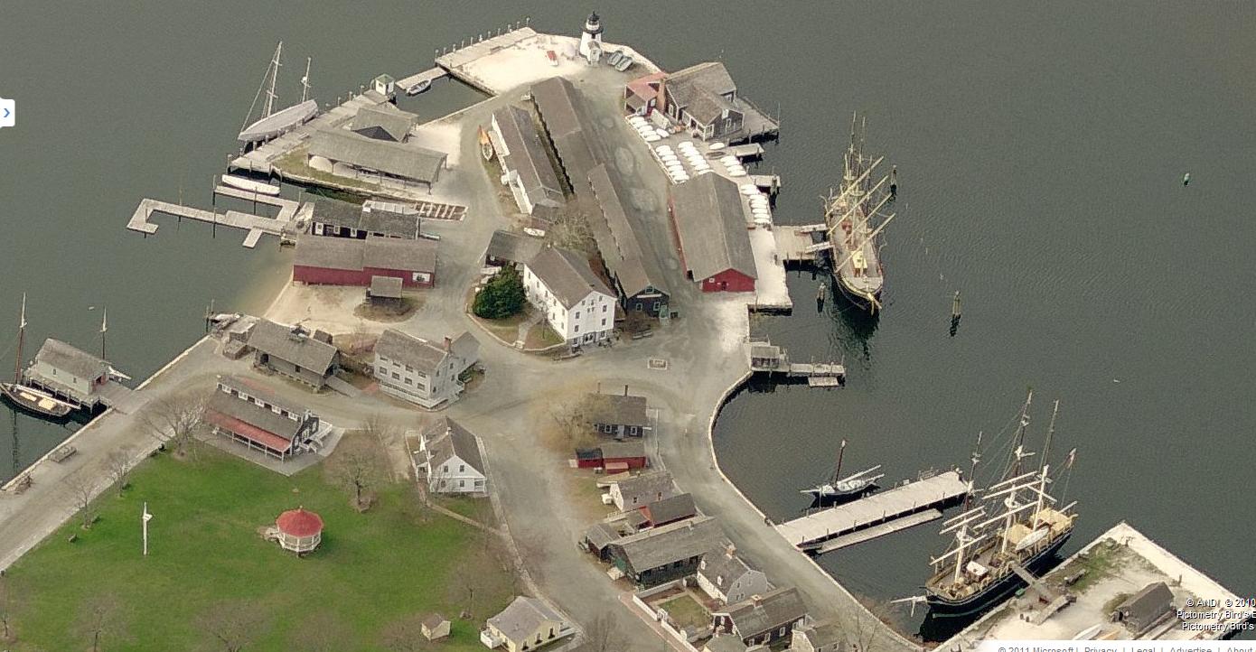
The air quality forecast for this weekend (shown below) makes me glad that SOS and some of the B&B Yacht Design team are in Mystic, Connecticut, for the 20th annual WoodenBoat Show. They will be exhibiting their boats and guiding folks who signed up to build a small sailboat on site.

Mystic Seaport venue  (Bing Maps)

SandyBottom is sea kayaking this weekend off Shackleford Banks.  She may have to cope with some haze but the forecast getting all her attention has been the one that mentioned high winds and big seas.

SandyBottom, et al. kayaking along Emerald Isle toward Shackleford Banks:  June 25th 11:30am. 
(SPOT)

Update: SB reported  "no haze,  huge waves, white knuckles going out Bogue Inlet".

Update:    SandyBottom, et al.  at Cape Lookout Lighthouse.   June 26  11:45am.
(SPOT) 

Meanwhile back here on the home front, sailing in clean air on Jordan Lake looks promising. 

Many coastal locations are dodging the haze, no doubt,  depending on wind directions and speeds.
Forecaste for June 26
(OuterBanksVoice.com)


Webcam in Oriental, NC.   June 25th at 10:50am.
(http://towndock.net/)


Where the smoke may drift:   Forecast for Saturday June 25, 2011
(NC Dept of Environment and Natural Resources,  Division of Air Quality )

Where the smoke may drift:  Forecast for Sunday June 26, 2011

Where the smoke may drift:  Forecast for Monday June 27, 2011


Update: One week later...
Where the smoke may drift:  Forecast for July 3-5


--DWSB